El Niño’s arrival is imminent and there’s a 90% chance it lasts all year, forecasters say
(NEXSTAR) – El Niño is likely to take over soon — and odds are it will be sticking around for a long time, national forecasters said in an update Thursday.
While the Northern Hemisphere is still under “ENSO-neutral” conditions — meaning we are neither in an El Niño nor La Niña — that could change at any time. The National Oceanic and Atmospheric Administration’s Climate Prediction Center said there is about an 80% chance the transition to El Niño takes place between May and July.
Once it takes hold, El Niño is likely to strengthen into the fall and winter, when it normally peaks. The odds of it lasting until February of 2024 are upwards of 90%, the Climate Prediction Center said.
An El Niño winter would be a switch from what what we’ve seen the last three years, with back to back to back La Niña seasons.
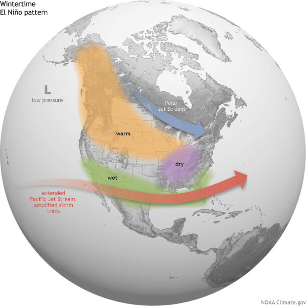
El Niño typically brings cold, wet winter to the Southern U.S. A strong El Niño in particular is associated with lots of rain for the Southwest and California — though California already saw a cold, wet winter this year even without El Niño in control.
On the other hand, El Niño usually means a warm, dry winter for the Pacific Northwest, Ohio Valley, northern Rockies and parts of the Midwest. Hawaii also often sees below-average rain during an El Niño fall, winter and spring season.
While El Niño can strengthen hurricane season in the central and eastern Pacific, it tends to contribute to weaker hurricanes forming in the Atlantic basin.
Even a strong El Niño isn’t a guarantee those exact scenarios will play out, NOAA warns.
“‘Associated with’ doesn’t mean that all of these impacts happen during every El Niño episode. However, they happen more often during El Niño than you’d expect by chance, and many of them have occurred during many El Niño events,” the agency writes.
Whether we’re in a La Niña year, El Niño year, or neither is determined by sea surface temperatures near the equator over the Pacific Ocean. The temperature of the water and air above it can shift the position of the jet stream, which impacts the types of weather observed on land.
Copyright 2023 Nexstar Media Inc. All rights reserved. This material may not be published, broadcast, rewritten, or redistributed. Regular the hill posts


