La Niña watch is officially on: How will weather be impacted in 2024?
(NEXSTAR) – El Niño hasn’t even grown cold, but national forecasters say its counterpart, La Niña, is already waiting in the wings to take over. The National Oceanic and Atmospheric Administration’s Climate Prediction Center issued a La Niña watch Thursday, predicting the U.S. will be in a La Niña pattern by the end of summer.
For the past nine months, we’ve been under a strong El Niño, which typically brings a cold, wet winter for southern states, and warmer, dry weather up north. Though we are still technically in an El Niño situation, NOAA meteorologists foresee it ending sometime between now and June.
Current conditions favor a switch to La Niña between June and August, NOAA said. It will likely grow stronger from there; La Niña and El Niño both tend to reach peak strength during winter.
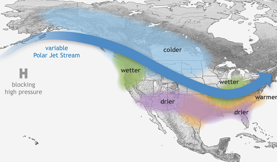
It’s winter when we’ll feel La Niña’s biggest impacts. A La Niña winter usually means dry, warmer-than-average conditions across the southern half of the country. The Pacific Northwest and Ohio Valley tend to get more precipitation, and northern states can see extra-cold weather.

When we’re in a La Niña, water along the Pacific coast is also colder and more nutrient dense, according the National Ocean Service. That’s also good news for marine life, like salmon and squid, that live along the West Coast.
Whether we’re in a La Niña year, El Niño year, or neither is determined by sea surface temperatures near the equator over the Pacific Ocean. The temperature of the water and air above it can shift the position of the jet stream, which impacts the types of weather we see on land.
The last time we saw La Niña conditions was just over a year ago, at the very start of 2023.
Copyright 2023 Nexstar Media Inc. All rights reserved. This material may not be published, broadcast, rewritten, or redistributed. Regular the hill posts


