‘Strong’ El Niño winter coming: Here’s where we could see more snow
(NEXSTAR) – In these uncertain times, we know at least one thing for sure: El Niño is here. There’s 100% certainty El Niño will last through early winter, the Climate Prediction Center, a division of the National Oceanic and Atmospheric Administration, recently said, and a 90% or higher chance it lasts into spring.
El Niño typically divides the country in half, but where the dividing line falls varies from year to year. The southern third to half of the United States, including California, is likely to be wetter during an El Niño winter. The Pacific Northwest and Ohio Valley are usually dry and warm.
While El Niño’s impacts are never a guarantee, the climate pattern tends to influence weather across the U.S. as it reaches peak strength in the winter.
Does that mean El Niño will bring winter storms and feet of snow? Not everywhere and not necessarily, explains Michelle L’Heureux, a meteorologist with the Climate Prediction Center, in an article last week.
“In fact, El Niño appears to be the great snowfall suppressor over most of North America.”
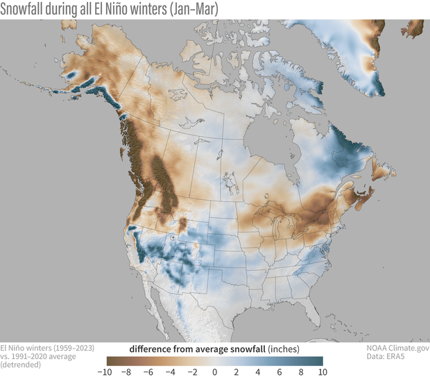
El Niño may bring extra precipitation to the southern half of the country, but it’s not always cold enough there to turn that moisture into snow. You do see some extra snow during El Niño winters in the mountainous regions of the West, like the Sierra Nevada mountain in California and the southern part of the Rocky Mountains.
Meanwhile, the Great Lakes, some of New England, the northern Rockies and the Pacific Northwest typically see less snow during an El Niño winter, L’Heureux says.
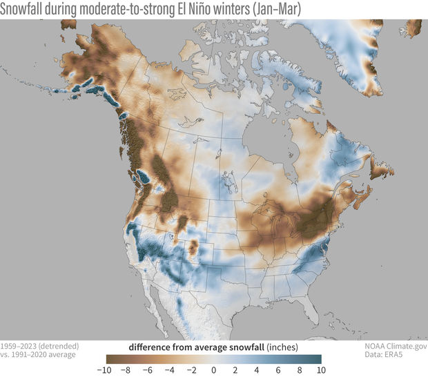
The areas that get more average snowfall in an El Niño winter are shaded in blue on the map below, while areas that see less snow are shaded in brown.

During a strong El Niño, like we are expecting to see this year, the effects are even more pronounced. More snow starts to show up in Northern California, the Four Corners states, the Texas and Oklahoma panhandles, and the southern Appalachia region.
The suppression of snow up north is also stronger during a powerful El Niño. States like Oregon, Washington, New York and Pennsylvania are the most likely to see below-average snowfall.

But before you pack away the snow gear, L’Heureux cautions against reading the data averages as a promise.
“El Niño nudges the odds in favor of certain climate outcomes, but never ensures them,” writes L’Heureux.
There’s also the impact of climate change, which has meant less snowy winters over time for much of the U.S. On the other hand, a freak snowstorm can always defy the odds, even during an El Niño year.
In its most recent outlook, the Climate Prediction Center said there is a 75% to 85% chance that we see a “strong” El Niño this winter. There’s a 30% chance it ends up being one of the strongest ever recorded.
Copyright 2023 Nexstar Media Inc. All rights reserved. This material may not be published, broadcast, rewritten, or redistributed. Regular the hill posts


