Why a triple-dip La Niña could be bad news

(NEXSTAR) – A rare triple-dip La Niña is looking increasingly likely for the Northern Hemisphere. The latest outlook by NOAA’s Climate Prediction Center, released Thursday, indicates there’s a 62% to 66% chance the current La Niña climate condition will persist through fall and early winter.
If that happens, it’ll be the third La Niña winter in a row – a rare phenomenon we’ve only seen twice since 1950.
A third consecutive La Niña year would likely have two major impacts: one in the southeastern U.S. and one out West.
“For the fall, the most significant aspect of it would be the potential for the hurricane season in the Atlantic, in particular, to stay energized and result in another active season,” said Mike Halpert, deputy director of the Climate Prediction Center.
La Niña years often correspond with busy and especially destructive hurricane seasons. Those conditions are already reflected in meteorologists’ 2022 outlooks. While an average year has about 14 named storms, Colorado State University predicts 20 named storms this year.
Once hurricane season passes at the end of November, we’ll start to see how a triple-dip La Niña would impact our winter weather. The La Niña climate pattern usually splits the country into two, bringing a dry winter to the southern half and a wetter winter to the northern half.
We don’t know exactly where the dividing line will fall this year, but if La Niña stays with us, we could expect dry conditions from California, through the Southwest, Texas and the Gulf and Southeastern states, Halpert said.
The biggest impact, however, will be felt out West.
“We’ve got significant, significant drought in the Southwest and California and their normal rainy season is the winter,” Halpert said. “Here in the Washington, D.C. area, it generally rains all year round. So if we have a couple of dry months, it’s OK because we can make it up another time. When you’re in California and the Southwest, 90% of the rain falls in that fairly short winter and spring season. So if you miss that, you’re not going to make that up when you get into the summertime.”
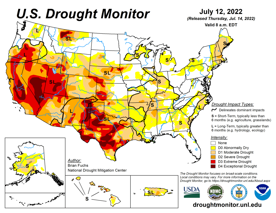
In short, a La Niña winter would likely mean making a very bad drought even worse for the band of states from California to Texas. The latest map from the U.S. Drought Monitor already shows extreme and exceptional drought conditions in many parts of the region.

La Niña could mean bad news for the southwest, but the opposite is actually true for Northern California and the Pacific Northwest, where La Niña winters tend to bring more precipitation, not less. There could also be more precipitation for the Midwest and parts of the South later in the winter, specifically Ohio and the Tennessee Valley.
Copyright 2023 Nexstar Media Inc. All rights reserved. This material may not be published, broadcast, rewritten, or redistributed. Regular the hill posts


